This type of orienteering allows EOOC members to do a course on ANY DAY, at ANY TIME, using an app downloaded to your smart phone, which will ‘beep’ at each control and time you, plus a map you have printed yourself*.
* or you can send the pdf to Staples (or other print shops?) to print.
You can do the course with app and printed map (for the best experience),
or just the app, (which will beep but does NOT have a control description)
or just the map with control descriptions.
Course styles
Some courses will be point-to-point (take controls in the correct order) like Wednesday courses used to be.
Some will be scatter style (visit controls in any order). You do not have to do all the controls.
NB: you could do any of the courses with just the printed map, but there may not be ribbons.
More things to do with independent courses
Personal safety
If you are going out completely on your own, tell someone where you are going, and notify them when you are back
Take your own water, ?sunscreen, ?bug spray etc.
Check the weather forecast before you set off.
The parks:
City Parks are open from 5am until 11pm Try to pick a quiet day and time to go.
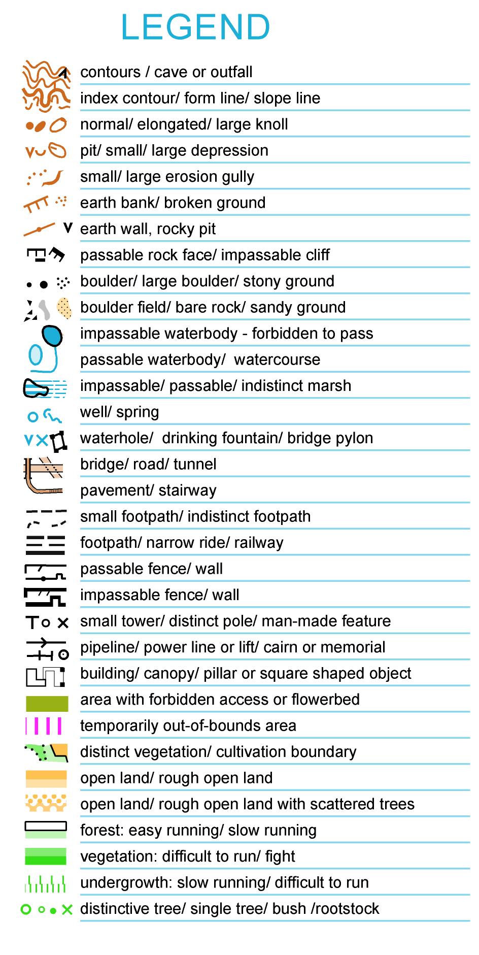
Map legend for most city park maps
Control descriptions to international standards, with illustrations starting at page 18.
Registration:
There is NO FEE to participate or to download the app.
Using the app:
Download MapRun6 from your preferred app store (eg Google Play or the APP store). MapRunF will still work if you already have that.
Click on Select Event: Canada – Alberta – Edmonton – name of event.
Press go to start; map and course will appear.
Check that it is the right map/course before you leave home!
If you get a list of changing numbers, tap the waving flag symbol.
Close the app. The icon for the app is a green square with the letter M & numeral 6 in it.
When you get to the park, open the app. At this stage you may be able to change the punch tolerance in the options and settings. 10 metres will be good for city parks (needs to be done every time). Click on Go to start
Before you go to the start triangle, it might be good to give your phone time to find some satellites. The green panel across the bottom will indicate what level of satellites your phone has found.
The app. does NOT use data while you are on the course. You can turn off data (many phones work better without data on). Turn off Bluetooth, too.
Approach and walk through the start triangle. The phone will beep/tone at the start, at each control, and at the finish. Each will turn green on the phone map as you reach them. If you are doing a scatter O or Score O, avoid going back through the start/finish until you HAVE finished.
If you have a printed copy of the map, you can put your phone in your pocket with the sound turned ON. (You will hear the phone beep, but it will be easier to read the paper map.) This will save your battery, too.
Results
After you have gone through the finish, you will be able to see your track. When you get back home to WiFi, open the app and click on ‘show results’. Select the event you just did, click ‘all results for this event’.
If your name is there, you are good. If your name is not there, go back one page. Choose menu (three bars, top right corner) Select Upload (Manual).
If you do this, we will know how many people have done the course (and the organizers will know whether it is worth doing more of them!).
Click on show details for your split times. If you did not use MapRun6, please email Marilyn to let her know what you did (and with whom)
GPS
The app works on GPS, which is not super accurate. Sometimes you will get the notification when you are approaching a control location; sometimes you might have to wait up to 30 seconds. Try turning round on the spot. If nothing happens, just go on to the next control, the same as you would if a ribbon was missing before Covid. GPS has problems in the trees and on slopes.
GPS seems to work better on a sunny clear day.
For improved performance, try turning off data (as the app does not use it); try waiting a few minutes after clicking Go to Start, and before actually going through the triangle.
How to use the check sites function
Open your MapRun6 app.
Click on the green button at the bottom right of the screen.
Click on the check sites icon (not on the words)
Type in the 6-digit code and click on OK.
Wait while it downloads*, then click on Go to the start.
* may take a long, long time!
Emergency BAIL OUT (especially for forest events)
If you are lost /do not know where you are, you can:
Click on home (little house) and then exit.
Click on Go to Start.
Stand still for a little while. A red dot will appear to show you where you are (perhaps you will have to zoom out to see it). You will now be able to head back to the finish, either the shortest way or by finishing the course and you will be able to see your track as you go. If you do all of the controls, you will be DNF’d (did not finish) but when you upload your results, you will see splits for the controls you found before bailing out.
Control description document Scroll to page 18 for sketches of each location and the matching piece of map.
Basic legend for the maps