On the Dalmuir map, 13km east of Redwater, in the Redwater Provincial Recreation Area. More location details below.
Available: from Saturday May 15, 2021, any day, any daylight hours (up to 2 hours before sunset.)
Differences from regular events:
For Orienteering Club members only.
NO registration banner, NO start banner, NO finish banner. NO direction signs. NO beginner instruction on site.
There are (assorted) orienteering flags at most sites, with the control code on the flag or ribbon, NO SI units, NO punches. Controls close to trails have ribbons instead. (Flags/ribbons not guaranteed to be there!)
NO fees, but we expect you to meet the requirements below.
Requirements: as well as the usual 2m physical distancing, following COVID-19 instructions from the authorities, and staying home if you are sick or required to self-isolate:
That you have a buddy or two out there at the same time as you (but not necessarily going out on the same course, nor arriving in the same vehicle) [compulsory]
Be self-sufficient: 2 printed copies of the course(s) you expect to do (one to give your buddy) [compulsory]
Courses downloaded at home from the MapRun6 (or equivalent) app if you are able.
a map bag, whistle [compulsory], compass [compulsory] .
water and snacks
Be aware of the weather forecast, so sunscreen/hat?
LONG PANTS recommended (against ticks and pokey branches)
Bug spray (eventually!)
Fully charged cell phone if possible (reception is quite good over all the map)
Small first aid kit (in a car)
Plenty of COMMON SENSE
Terrain:
Sandhill terrain with subtle hills. 5m contour interval. Main trails are sandy and churned up by ATVs and dirt bikes – tough to walk along. Deadfall is shown marked with wide- or narrow- spaced vertical green lines or solid green. Map revised for 2021.
Courses:
These courses are to classic standards.
NO absolute beginner or Novice course.
There are 4 courses, all different from last year and with different control locations.
The easiest one is labelled Intermediate. The other three are technically advanced and vary in length.
Hazards:
Wild animals (rare)
ATV and dirt bikes – very loud, but they scare away the wild life, and the operators are generally polite. If you are on a trail, be prepared to step off the trail if you hear them coming.
New trails made by the OHVs since last year.
Check for ticks when you get home (we don’t want you to be the first club member to get Lyme disease).
Safety:
Safety Bearing for all the courses is WEST TO THE ROAD.
If you are using the app, there’s an easy way of bailing out if you are lost/confused, explained in the last paragraph on the independent page.
Give your second copy of the map to your buddy. Arrange with your buddy a time at which you will meet after doing the courses.
Nearest Hospital: at the west end of Redwater 780-942-3932 has an emergency dept. From the event site, go north to the T-junction. Go west/left on Twp 574 for about 13km in a straight line. Road designation/surface changes several times. Shown on the location map.
RCMP detachment 780-942-3607 is next door to the Hospital.
9-1-1 works for all emergencies.
Directions:
Northern Simple Route: Take Hwy 28 north to the Redwater turn-off. After the realignment bend, drive straight i.e. due EAST, for approx 13km. The road changes from paved to gravel, and the road number changes TWICE! Just drive straight. At RR 205, turn right/south. Park at the finish location [unmarked] about 700m south of the open area (where the ATVers park, visible on your O map), or ~ 3 km north of Victoria Trail.
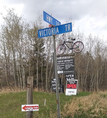
Or via Fort Saskatchewan, then northeast on Hwy 15, north on SH 830, west on Hwy 38, crossing the Vinca Bridge. Then turn north onto Victoria Trail at the Den of Antiquity sign. After 3- 4km, turn left at RR 205
Park at the finish location [unmarked] about 700m south of the open area (where the ATVers park, visible on your O map), or ~3 km north of Victoria Trail.
Or via the Ugly Industrial route, Manning Drive, north on SH 825, east on SH 643, then east (right) on Hwy 38 . Then turn north onto Victoria Trail at the Den of Antiquity sign. After about 3-4km, turn left at RR 205.
Park at the finish location [unmarked] about 700m south of the open area (where the ATVers park, which is visible on your O map), or ~3 km north of Victoria Trail.
Location map here: www.orienteer.ab.ca/locations/dalmuir5location/
Organizer: Geraint Edmunds, Orienteering Canada level 300 official and MapRun administrator for Alberta.
Thanks to Judy, Beth, Einar, Greg and Marilyn for help vetting the courses.