White Earth 2018 B Event — Event Details
Saturday and Sunday July 21 and 22. Same courses both days. Choose one, or come both days.
On the White Earth map, near Smoky Lake. About a 1.75 hr. trip from Edmonton.
Register and Start from 11:30 pm – 1pm, and finish no later than 4pm. (Help with control pick-up would be much-appreciated on the Sunday!)
Format: Four courses
- beginner/novice (along trails, controls just off trails); beginners’ clinics available.
- intermediate course; controls across country with something to catch you from going too far (such as a trail or large hill). Compass skills and choosing routes needed.
- a shorter technical course of about 4.5 km.
- a longer technical course (about 6.5 km long).
Fees: $10 per annual member individual/couple/family. Fee includes a map, rental of SPORTident timing card, rental of compass and whistle if you don’t have your own.
$15 per member-for-a-day individual/couple/family. Fee includes a map, rental of SPORTident timing card, rental of compass and whistle if you don’t have your own.
$5 per additional map for couples/families going out together.
Driver’s license required as deposit for rentals.
NB if you come both days, we will not charge you for the second day (but you will still still need to sign a lilac waiver).
What to bring: Clothes suitable for the weather, sunscreen, your own water supply to carry if it’s VERY hot, bug juice. Compass and whistle if you have your own.
Other Attractions to make it even more worth your while coming (via the S. route):
- Map is quite close to the historic Victoria Settlement and Metis Crossing. Well worth a visit: original buildings, interpretive staff. Take Victoria Trail off Hwy. 855, just N of the river.
- You can visit Skaro Shrine, built in 1919 as a replica of the Grotto of Lourdes. NW corner of Hwys. 45 & 831.
- Lots of lovely Ukrainian Orthodox Churches, including historic (1904) Pakan Church.
On Saturday 10am until noon, there’s a Farmers’ Market at the Smoky Lake Agriplex (northeast part of town, visible from Hwy 28)
Organizers: Wayne Best (ED/CP). Kim K (O300 official, controller)
Location:
Directions: From SH 855, about five miles south of Smoky Lake and about three miles north of the river, turn east on TWP Rd. 584, continue east 6.5km to Range Rd. 170, turn north for a few hundred meters, turn east on TWP Rd. 584A, follow this road for about 8km (it mysteriously changes name) until you find us where a large cutline crosses the road. Park on the left-hand (north) side please, so we don’t impede any other traffic.
Northern route: follow Hwy 28 from the city to about 9km past the Smoky Lake Hospital and just BEFORE the road crosses the White Earth River, then turn right/south down RR162. At the T-junction, turn left. The road turns south again. At the next T-junction, turn right. The meeting point will be about 1km down this road.
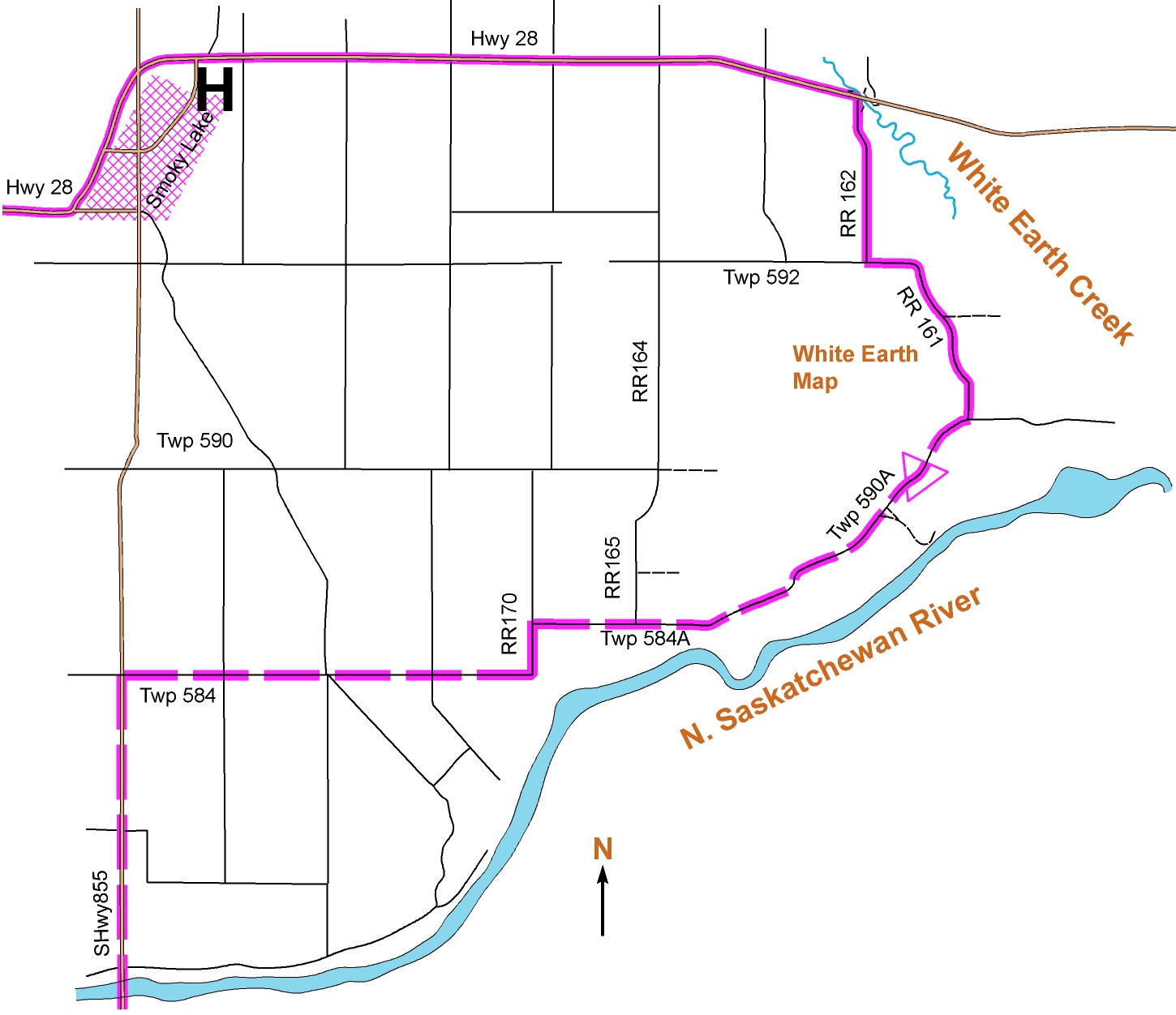
Location map available separately here: White Earth 2 Location
Coordinates 54.06345, -112.28885