Classic Independent courses in Redwater Natural Area.
On the Dalmuir map, 13km east of Redwater, in the Redwater Natural Area. More location details below.
These courses are on the same map as the middle distance ones, with the same start/finish area and some of the same control locations. These are CLASSIC distance courses, which have longer legs (consequently more route choice).
Note: If this is your first time on a forest map, you may find it easier to try one of the middle distance courses
IMPORTANT: we cannot guarantee that all the flags and ribbons are still in place – wildlife tend to take them!
Differences from regular events:
For Orienteering Club members only.
NO registration banner, NO start banner, NO finish banner. NO direction signs. NO beginner instruction on site.
There
are (assorted) orienteering flags at most sites, but they have NO
numbers, NO SI units, NO punches. The two easier courses have ribbons
at some controls instead of flags – the ribbons do have numbers.
NO fees, but we expect you to meet the requirements below.
Requirements: as well as the usual 2m physical distancing, following COVID-19 instructions from the authorities, and staying home if you are sick or required to self-isolate:
[compulsory] That you have a buddy or two out there at the same time as you (but not necessarily going out on the same course, nor arriving in the same vehicle)
[compulsory] that you are self-sufficient: including 2 printed copies of the course(s) you expect to do (one to give your buddy)
Courses downloaded at home from the MapRunF app if you are able, and the code written down for all of them.
a map bag, whistle [compulsory], compass [compulsory] .
water (lots as these are longer courses and you may be further from the road) and snacks.
Be aware of the weather forecast, so sunscreen/hat?
LONG PANTS recommended (against ticks and pokey branches)
Bug spray !!!!!!!
Sanitizer
Fully charged cell phone if possible (reception is quite good over all the map)
Small first aid kit (in a car)
There are toilets at the ATV parking area (but bring some toilet tissue)
Plenty of COMMON SENSE
Terrain:
Sandhill terrain with subtle hills. 2.5m contour interval. Main trails are sandy and churned up by ATVs and dirt bikes – tough to walk along. Deadfall is shown marked with wide- or narrow- spaced vertical green lines. Some newer deadfall not marked.
Hazards:
Wild animals
ATV and dirt bikes –
very loud, but they scare away the wild life, and the operators are
generally polite. If you are on a trail, be prepared to step off the
trail if you hear them coming.
Check for ticks when you get home (we don’t want you to be the first club member to get Lyme disease).
Safety:
Safety Bearing for all the CLASSIC distance courses is WEST TO THE ROAD.
If you are using the app, there’s an easy way of bailing out if you are lost/confused, explained in the last paragraph on the independent page.
Give your second copy of the map to your buddy. Arrange with your buddy a time at which you will meet after doing the courses.
Nearest Hospital: at the west end of Redwater 780-942-3932 has an emergency dept. From the event site, go north to the T-junction. Go west/left on Twp 574 for about 13km in a straight line. Road designation/surface changes several times. Shown on the location map.
RCMP detachment 780-942-3607 is next door to the Hospital.
9-1-1 works for all emergencies.
Courses:
These courses are to CLASSIC Distance standards – with longer legs.
Choose by Technical Difficulty NOT by length. NO absolute beginner course. No beginner instruction available on site.
TD2 a novice course, 2.8km with 13 controls on or next to trails. Orange/white diagonal stripe tape or occasional flag. Use your compass to keep the map oriented.
TD3 an intermediate course, 3.9km with 12 controls, up to 100m from a trail. Some route choice. Use a compass to check whether you are on the correct trail.
TD4 4.4km long with 14 controls, lots of route choice, use of catching features and aiming off.
Three other advanced courses which will be sent to anyone who completes course 4 in a reasonable amount of time. These each have at least one leg which is 1km long.
Directions:
Northern Simple Route: Take Hwy 28 north to the Redwater turn-off. After the realignment bend, (passing Tim Horton’s, Hospital, RCMP detachment) drive straight i.e. due EAST, for approx 13km. The road changes from paved to gravel, and the road number changes TWICE! Just drive straight. At RR 205, turn right/south. Start/finish location [unmarked] will be 1km south of the open area (where the ATVers park), or 2.7km north of Victoria Trail.
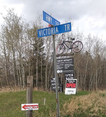
Or via Fort Saskatchewan, then northeast on Hwy 15, north on SH 830, west on Hwy 38, crossing the Vinca Bridge. Then turn north onto Victoria Trail at the Den of Antiquity sign. After 3- 4km, turn left at RR 205
Start/finish location [unmarked] will be on the EAST side of RR 205, 2.7km north of Victoria Trail and 1km south of the open area (the ATVers parking lot).
Or via the Ugly Industrial route, Manning Drive, north on SH 825, east on SH 643, then east (right) on Hwy 38 . Then turn north onto Victoria Trail at the Den of Antiquity sign. After about 3-4km, turn left at RR 205.
Start/finish location [unmarked] will be on the EAST side of RR205, 2.7km north of Victoria Trail and 1km south of the open area (the ATVers parking lot).
Or enter GPS coordinates N53.929 W112.951 into your phone or in Google maps.
Location map here: www.orienteer.ab.ca/locations/dalmuir5location/
Organizer: Geraint Edmunds, Orienteering Canada level 300 official.