Blackfoot Score ‘O’ 2023, Sunday, May 28th
Location: Central Staging Area, Blackfoot Provincial Recreation Area
Weather Forecast
Options: Choose 1 hour, 3 hour or 6 hour time limit.
NEW: there is one map with just the SPORTident controls (estimate of 15km to visit them all if you make no mistakes.)
On-line registration OPEN Please register, so we can print map(s) for you!
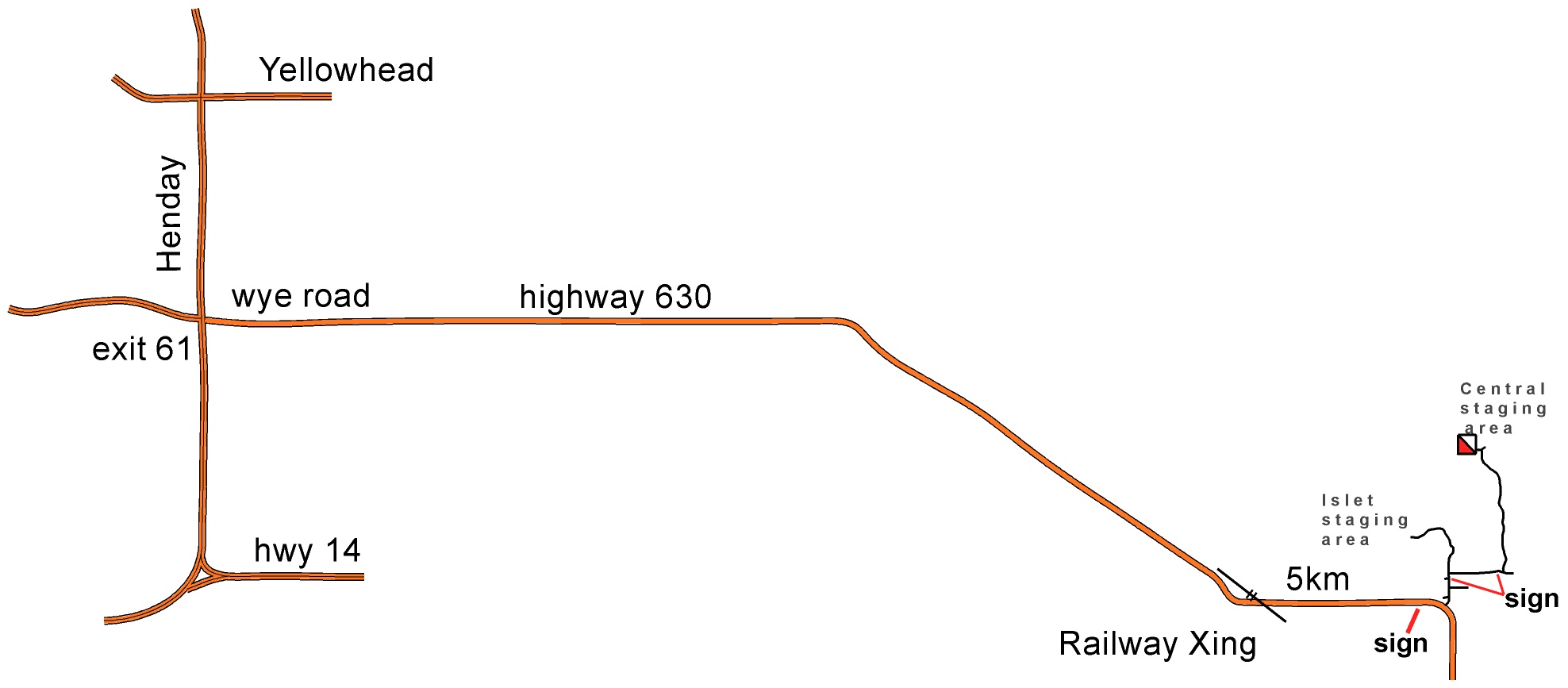
Location
Cooking Lake / Blackfoot Provincial Recreation Area is sign-posted from the 90 degree bend in Hwy 630 where it changes from N/S from Hwy 14 and E/W from Sherwood Park. From there, follow the blue signs for Central Staging Area.
Google will find it if you enter ‘Central Staging Area, Blackfoot PRA’
Better than average outhouses next to the shelter
Format:
Some controls with SPORTident and flags, close enough to each other for the all participants to get a good score. Some of those in the grazing fields.
Also lots more ‘virtual’ controls which can be scored by using the MapRun app. These are further apart and further away from the start/finish than the real controls. There are controls in the wooded areas.
For both kinds, points are won by finding controls and lost by being over the chosen time limit.
Scoring: your time starts when you punch the SPORTident start unit and finishes when you punch in at the SPORTident finish unit. The officials will calculate and deduct points, if necessary, of 10 points for each minute you are over time. (NO bonus for being back early).
Points for visiting the controls, whether real or virtual, are the usual standard:
50 points for any control numbered in the 50 series e.g. # 57 gets you 50 points, so does #51
80 points for any of the 80 series e.g. #88 gets you 80 points, so does #83.
and so on.
You will be able to tell from the control description whether a control is real or virtual.
Real controls need to be ‘punched’ but will not get a MapRun beep. Virtual controls will beep and maybe have a ribbon, but do not have an SI unit.
You can do this on your own or in a small group (partner or small family group)
You may visit the controls in any order, including changing back and forth between real and virtual.
Morning registration and map hand out
10:00 – 10:55 on-site registration and map hand out for all three versions.
All participants will have up to 15 minutes to look at their map and plan* – from when they are given their map until 15 minutes later or until they punch the start control (whichever comes sooner).
Mass start for those who like them at 10:30am. OR a less stressful punch start when you are ready.
Better than average outhouses near registration. Pit toilets marked on the maps for the 3 hour and 6 hour versions.
* help available from the organizers.
Afternoon on-site registration and map hand out
12:15pm – 12:55pm on-site for 1 hour and 3 hour events. All participants will have up to 15 minutes to look at their map and plan* – from when they are given their map until 15 minutes later or until they punch the start control (whichever comes sooner).
*help available from the organizers.
Course closing: for all events, everyone must be back by 5:00pm.
What to take out with you:
-whistle (compulsory) any kind will do
– compass (loaners available)
– more water than you think you will need (none on the site) and snacks
– fully charged cell phone if you can (reasonable coverage over most of the map). Organizers’ phone # will be be printed on the map.
– depending on your choice of time limit, other things that you would take on a long hike, such as a hat, sun screen, insect repellent, spare socks, small first aid kit.
– the 6 hour limit probably needs a fully charged smart phone (rather than a watch)
Entry Fees: Individuals or small Groups $20. Extra maps $5. The same fee for whichever time limit you choose. You do not need to choose which until the day! Includes SPORTident rental and loan of compass and/or whistle if you do not have your own.
On-line registration OPEN
Planner’s Notes: by Geraint.
A key feature of this event is that it is on a very large brand new map. It is the first map that we have made almost entirely from aerial data, (high quality LiDAR and Google Earth) with minimal fieldwork. My confidence levels are as follows:
- high confidence in the contours,
- reasonable confidence in the vegetation, though some outlying regions have just the OCAD produced basemap without more detailed evaluation (the greens are slightly different in how they appear).
- less confidence in the water features because they were based on 2020 google earth pictures (wet year and difficult to interpret the marshes) plus LiDAR intensity plot flown in April 2018 when snow melt may have made some areas look more marshy than they really are. Beaver activity is a confounding factor. While out control hanging, the marshes in general seemed pretty dry.
- The major roads and ski trails are accurate. Other trail information in the wooded areas is mainly base on GPS tracks where we happen to have been. There are many minor game trails not marked on the map, especially in the white or light green areas.
- Any controls without ribbons are in areas where no organizer has been. Feedback on the map in those locations would be greatly appreciated (photos?)
The event used computer assisted control hanging (or not hanging) and computer assisted scoring. To enhance the dopamine rush, there will be real beeping and flashing controls with SPORTident electronic timing for 32 controls closer to the Start/Finish location. Further out, the control spacing will increase and use virtual MapRun type controls. Many of them also have ribbons with prove you were there symbols on them in case your device battery runs out early. (My experience is the battery lasts longer on a phone than on a watch). An option is to do an SI loop first and then go back through the start to begin the Maprun section.
The magic of Google Earth, MapRun7, Route gadget, GPS, etc. all assisted with control placement and scoring. Condes course planning software was the key helper for scoring. It has a Rogaine (Score) option for assigning points to a control based on the control number, 30 points for 31 or 33, 40 points for 45 and 80 points for control 89. If we have the time and the weather, we may hang ribbons at all the virtual control locations, (I suppose we should make sure they are accessible).
You can visit the controls in any order (including swapping back and forth between the kinds of controls).
Rogaines (a type of score event) typically allow planning time before the start of the race. I used the Rogaine scoring system so, to be fair to competitors, l will aim to have the virtual part of the course available for download to your phone about 24 hours before the start. You can also look at your paper map for a few minutes before you start.
Course closing: for all events, everyone must be back by 5:00pm.