Notes from the course planners:
There is NO drinking water on any of the courses. Water will be available at the FINISH area.
Contactless punching is NOT available at this event. Any SI card will work… you need to punch your control the old-fashioned way, dip the card into the control unit, listen for the beep and look for the flash.
As of Tuesday, April 28th, water levels were low in the marshes and some of the small marshes were dry. Marshes were crossable.
We didn’t see any mosquitoes while we were out checking control sites. But, if we get rain, that may change. Bring your bug spray just in case!
Deadfall is considerable in some areas and may influence your route choices. There are a few small, distinct trails in the terrain that are not on the map. Take care with your navigation.
The long-range forecast for Saturday is for a warm, sunny day! But, we are in Alberta so don’t forget to bring along clothes for 3 seasons: a jacket, sun hat and anything else you think you may need.
Details
| Map | Morningside 1:10,000; 2.5 m contours; Original fieldwork – Kitty Jones (1983), latest update – Don Riddle (2023) |
| Location | 3 km south of Morningside, an hour south of Edmonton city limits. See directions and location map below. |
| Registration | on-site from 11:00 A.M. until 1:00 P.M. (beginner clinics available at the same time) |
| Starts | 11:00 A.M. until 1:00 P.M. |
| Courses close | 3:30 P.M. – everyone must check back in by this time |
Courses (lengths approximate):
| Course | Notes | Length | # Controls |
|---|---|---|---|
| 1. Beginner/Novice (td1/2) | Controls on paths to start with, then controls within 20 – 30 m of linear features such as trails, fences | 2.8 km | 17 |
| 3. Intermediate (td3) | 3.9 km | 15 | |
| 4. Short Advanced (td5) technically difficult: | 4.3 km | 13 | |
| 5. Advanced (td5) technically difficult | 6.1 km | 19 |
Terrain: Aspen Parkland underlain by ancient sand dunes. Over 18 km of trails wind through a mosaic of shrub-lands, aspen groves, stands of white spruce on moist shady hill sides, wetlands and grass meadows. Entire one-mile-square area is surrounded by a border fence (no need to worry about wandering away!) Area is detailed with many small hills, depressions and a few large marshes; variable vegetation ranges from open meadows to runnable open forest with some patches of thick undergrowth and deadfall.
Fees & Registration
Fees:
Adult members: $15 on the day / $12 advance registration
Adult non-members: $20 on the day / $17 advance registration
Junior members: FREE on the day / FREE advance registration
Junior non-members: $5 on the day / $5 advance registration
Group rate: $25 onsite / $20 advance registration
On-line registration closes at 7 p.m., Thursday, May 7th.
Fee includes rental of SPORTident electronic timing card, plus, if necessary, compass and whistle. (Deposit of driver’s permit required for rentals)
Questions? contact info@orienteer.ab.ca
What to bring:
Whistle compulsory – any kind will do. A group needs only one between them.
Watch/ time piece strongly advised, to remind you of the 3:30 p.m. closing time.
Be prepared for any weather – jacket and warm underwear if it’s cool; hat and sun-screen if it’s sunny. Long pants recommended. Dry socks to change into. Water and cookies provided.
Optional: camera, picnic.
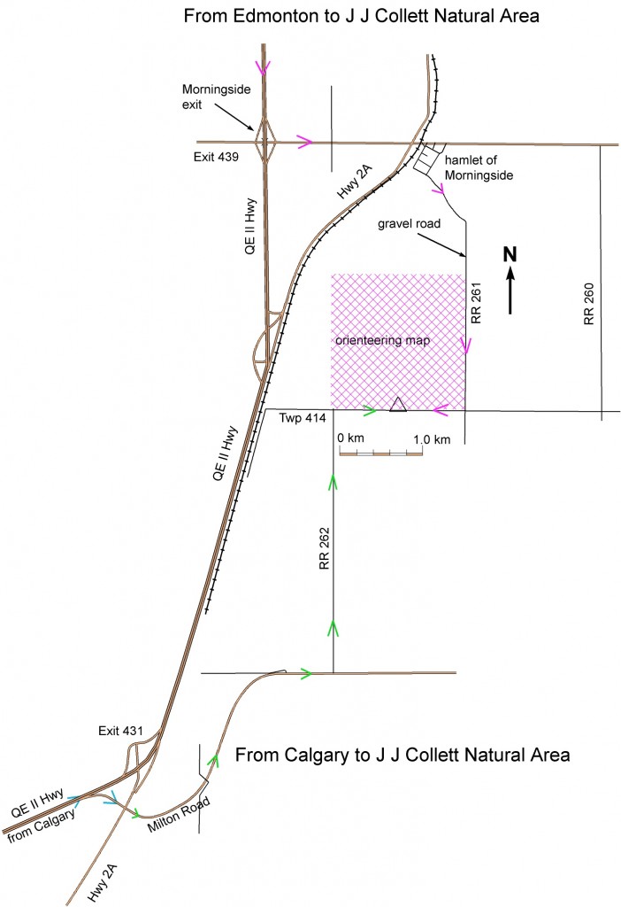
Directions:
From Edmonton take QEII Hwy south to the Morningside exit #439. Turn left onto SH 604 and go under the bridge. After crossing Hwy 2A and the railway tracks, turn right into the village of Morningside. At the far end of the village (3 blocks), turn left. Follow this road (RR 261A / 261) for 3.5km. At the crossroads, turn right onto Twp 414. The entrance to the J J Collett Natural Area is about 800m on the right. Park in the parking lot or on the side of the road and walk in through the gate. Watch for orienteering signs, as well as NEW signs to the JJ Collett Natural Area.
From Calgary: take exit 431, follow Milton Road until RR262. Go north about 3km on RR 262 to the T-junction. Turn east/right on Twp414. The entrance to the J J Collett Natural Area is about 800m on the left. Park in the parking lot or neatly on the side of the road, and walk in through the gate. Watch for orienteering signs, as well as NEW signs to the JJ Collett Natural Area.